
Iowa Impaired Ponds and Lakes
What is an impaired waterbody?The U.S. EPA defines an impaired waterbody as "a waterbody (i.e., stream reaches, lakes, waterbody segments) with chronic or recurring monitored violations of the applicable numeric and/or narrative water quality criteria" where water quality is "the biological, chemical, and physical conditions of a waterbody. It is a measure of a waterbody's ability to support beneficial uses." When applicable water quality standards are not being attained, a total maximum daily load (TDML) or alternative restoration plan to reduce pollutant loadings is set with the goal of restoring the waterbody.
What causes impairment?On average, over 250 million people worldwide succumb to diseases related to water pollution (Conserve Energy Future, 2013). To understand the science behind the problem of water pollution, one must look at the two major water systems: surface water and ground water. Both systems are significant to Iowans, because both systems are used to supply drinking water for people, livestock, irrigation, and industrial production. Both surface water (the water we see in streams, rivers, wetlands, and lakes), and groundwater (which is stored in aquifers below the surface) can be affected by pollution.
|
|
As shown in the map below, 74 out of 165 lakes over 0.7 acres in size are impaired in Iowa. (Source: United States EPA 2012)
Non-point pollutionBy sheer volume, non-point source pollution is Iowa’s largest and most threatening water quality problem (EPA). Non-point pollution is created when rainfall, or snowmelt runs over or through the ground and picks up contaminants, depositing them into streams, lakes, rivers, or groundwater. The most common non-point pollutants are soil (sediment) and nutrients that are picked up and deposited elsewhere through stormwater runoff. Other common pollutants include pesticides, pathogens (bacteria and viruses), salts, oil and grease.
Impaired lakesIowa’s 2012 Section 303(d) list of impaired waters contains 480 waterbodies with a total of 642 impairments. This includes 388 stream/river segments, 74 lakes, 7 segments of three federal flood control reservoirs, and 11 wetlands and is a subset of the 1,227 waterbodies.
Each water body is assessed by IDNR staff to support their designated beneficial uses. These beneficial uses (primary contact recreation, aquatic life, drinking water, fish consumption, and general uses) are described in the Iowa Water Quality Standards as part of the Clean Water Act Section 305(b) (Iowa's 2012 List of Impaired Waters Fact Sheet, IDNR). As seen in the Searchable Impaired Lakes Map, impaired waters are separated into Category 5 (impaired and TMDL needed) and Category 4 (impaired but TMDL not required). Total Maximum Daily Load (TMDL) is the sum of the individual allowed waste discharges at a single point or from nonpoint sources. Best Management Practices like vegetated buffers and wetlands decrease nonpoint sources and reduce pollutants entering a lake (EPA). |
Impaired lakes in Iowa (2012)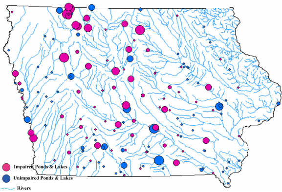
|
Percent impaired (2012)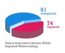
|
Types of impairmentsPollutants change the chemical properties of water, and floating material like algae and sediment obstruct light needed for many aquatic life forms. The image below shows the number of lakes in which each impairment occurred.
|
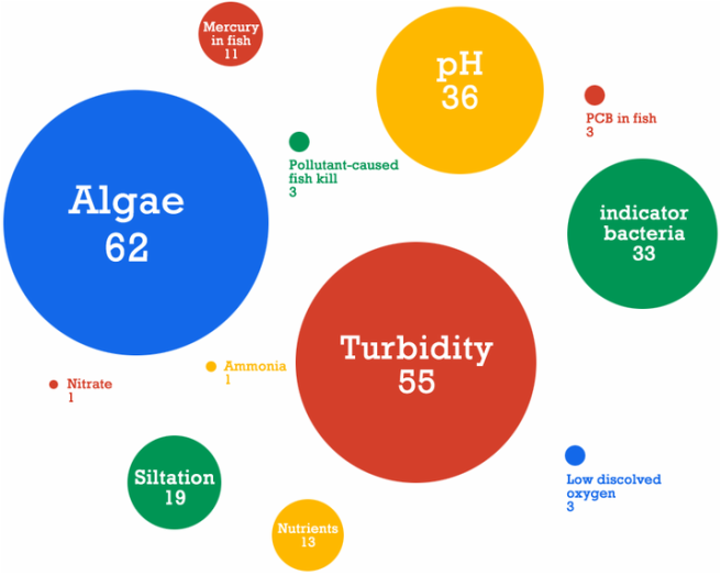
Number of river & stream impairments identified in Iowa's 2012 Integrated Report (Categories 4 & 5)
Impact of impaired lakes in IowaMany rural and urban small ponds and lakes across Iowa and the region have eutrophic conditions with high levels of nutrients and low levels of oxygen. This is why we see algal blooms and why many lakes aren’t safe for drinking or recreation. Healthy lakes are important because they intercept pollution from their watershed and have the potential to improve water quality downstream.
Searchable impaired lakes mapAs an example of water impairment in Iowa there is a subset of 165 lakes monitored by the DNR. In 2012, there were 74 DNR-monitored impaired lakes in Iowa's section 303(d) list, some with multiple types of impairments. The impaired and non-impaired lakes included in the Searchable Impaired Lakes Map are lakes monitored by the DNR. Please use the interactive map below to find major lakes near you that are designated impaired.
|


|
Lake data legend (data appears when you click on an impaired lake)
GIS data: Iowa NRGIS Library, iowadnr.gov
|
